There is much to write about regarding my late June trip to the arctic, and little time to do so due to another scheduled photo trip in which I’ll float a river out of the Brooks range in the Arctic National Wildlife Refuge. More about that upon my return. Looking back on the last week, the region I visited is little known, and the map below will give some reference for those not familiar with the National Petroleum Reserve Alaska, and its expansive acreage.

Map of the National Petroleum Reserve Alaska. I was near the red arrow.
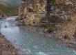
I was in the Uplands of the Utukok river, which flows north into the Arctic Ocean, just north of Point Lay, Alaska (beginning just west of the Coleville river). Access is by bush plane, and I flew with Coyote Air, out of Coldfoot, Alaska. That’s a long 2.5 hour flight across the Brooks range, which in itself is an experience to humble the proudest soul on the planet, unless they are inert to the power of all organic matter. The views are epic, and silence in the viewing is common for the first time visitor.
I was dropped off on a ridge that separates the Utukok from the Kokolik rivers, in an east to west orientation. At 1800 ft., it might not sound high, but for the edge of the arctic north slope, that is about the highest ridge in the area, and I had a 360 degree view for hundreds of miles in all directions. No trees, no setting sun, voracious winds, and a geographic solitude of an uncommon order. Alone on a ridge, my very skillful pilot (Dirk Nickish) left me and buzzed off into the distance, vanishing slowly as I photographed the departure. Shortly after, I realized that 90% of my food in a bear proof barrel also vanished into the distance, forgotten in the cab of the airplane (for those unfamiliar with camping in bear country, a bear-proof container to secure your food is essential for a host of obvious reasons). Hmmm….. I began a mental rationing plan of the small amount of food I had in a stuff sack, considering although I would be hungry and might lose a few pounds, I could survive. At the same time, I knew Dirk would find the barrel when dropping off the other passengers going further east. But… Doing an air drop or landing again with a back-haul plane load of six people was going to be a challenge. I knew he would not land up there with a full load. Within an hour or so, I heard his plane again, and he circled once, came around very low and very slow, and suddenly out of the other side of the plane, out popped the bear barrel, bounced on the tundra and tumbled vigorously until stopping (all in one piece), upon which I happily ran to secure it. Dirk tipped a wing and flew off again into the distance. Dirk, you are awesome!

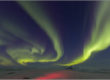
The first few days some interesting clouds filled the sky, the last three days were nearly cloud-free.
I set up base camp, from which I made daily hiking forays, both east and west looking for photographic subjects. I averaged about 15-18 miles a day, schlepping 35 lbs of camera gear across the ridge and tundra as the big ball of fire in the sky whirled around me in a subtle but consistent torment. Harsh daylight shifted my photography schedule to the 10pm to 5am period. It is difficult to put the odd blend of loneliness, solitude, fear, invigoration, and magnificence of landscape into words. It’s an encounter. A wonderful one mixed with many feelings and a very primordial connection with the land. Native Alaskans roamed this part of the earth as long as 12,000 years ago, according to archaeological evidence found at the Mesa Site, not too far from the Utukok Uplands.
I watched the wind’s furry in the tenacious flowering tundra, abundant and vocal nesting birds, migrating caribou, ground squirrels, marmots, and last but not least…way too many grizzly bears. And speaking of the latter, I’ll write about my stand off with a grizzly bear on the ridge top in an upcoming post. That was just plain scary.
Below are a few photos of the area. I’ll be posting more from my trip over the next week or so.

12:08 AM, June 21, solstice, overlooking the Utukok river, National Petroleum Reserve Alaska.

Navigating tussocks! National Petroleum Reserve Alaska. If you have hiked through tussocks for any length of time, this photo may be an unpleasant reminder.


Solstice was my 50th b-day and I climbed a 3000 ft peak near town and skiid in pea soup fog… not quite the view you had on the same day! Hope you had some wildlife photo ops, too. The plover you posted is a black-bellied and not one of the goldens. The bear encounter in the open terrain has to be intimidating. Anxious to hear and see more, Patrick.
Milo,
A vastly different experience indeed! I’m shy on you by a few years, but may we both be doing these ventures for many more years to come.
I looked again and retract my plover ID. You were right the first time!
Hello Patrick
What a strange mix of emotions you induce with your words and photographs. Exhilaration, fear, wonder. Ache to be surrounded by nothing and everything. One day, I too would like to be dropped off alone, but without perhaps the threat of certain mild starvation (and perhaps a grizzly encounter that you will relate to bated breaths- will call Robyn over when the next installment hits the press).
Mark,
I thought of you and Robyn on my venture, reflecting on your trek in the Brooks range last summer. I know you are keen on the raw and open wilderness of the Brooks range and should you make it back to AK we should organize a trek into its great expanse. Meanwhile, I’ll be hopefully dreaming of visiting the land of lions and hyenas with you.
Pat….the map is very helpful. Such an expanse, and so wild. Hope to hear the stories first hand soon.
Soon Daniel, soon.
Sounds like the sound of an amazing adventure and I am sure the photos will be something else! What an intrepid photographer you are, Patrick. I am curious about those tussock grass clumps, though…methinks they are nothing like the ones on Steeple Jason?
Marissa,
You are right about those tussocks, they don’t quite have the grassy caps that the ones at Steeple Jason do! They are treacherous to travel through however.
I was looking for aerial photography of Coldfoot airstrip and came across your blog – what wonderful Sunday afternoon viewing for a long time Fairbanks resident, now long removed. Beautiful! Thanks for your work.
Tim, thanks for your kind comments. Did you find the shot of the Coldfoot airstrip you were looking for?
I love these pics and your description is perfect. I was in the National Petroleum Preserve from June 7 to the 18th with the Sierra Club and it was an awesome experience. We traveled from the Utukok to the Kokolik and it was just breathtaking. We were in the company of caribou the entire time. We saw fox, wolverine, weasels, ground squirrel, and many many birds. Some of our group saw a grizzly with a cub. Thanks for this website.
Debbie,
I flew in with Bob and Brian a few days before you left. A great area indeed. I was hoping to see a wolverine, since the area is well known for that, but no luck this time.
Patrick,
Yes, I think we were very lucky to see a wolverine. He was magnificent and very curious about us. We flew out of Kotzebue with Golden Eagle Outfitters. They were great at landing on the ridge. I will look forward to checking in on your pics and adventures.
The Reserve information and wonderful views will be so educational and enlightening to the global viewer, particularly with economic globalization and the oil business. Oh, to keep it so undisturbed from humanity’s greed!
Carolyn,
I concur.
Patrick